Story
Maya was one of the great Pre-Colombian civilizations, extending throughout the northern Central American region, including the present-day Guatemala, Belize, El Salvador, southern Mexico (Yucatan Peninsula) and western Honduras. The most notable monuments from this period (250–900 AD) are the ancient Mayan temples that were built in almost every important Maya city. Then for some unknown reasons, most of the Maya centers went into decline about the same time and were eventually abandoned leaving just the ruins. Even those were taken over by jungles and were only recently discovered.
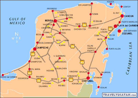
Where do you start for Mayan Ruins - Yucatan Peninsula, of course. Here is a map.
Of Top 10 most beautiful ancient Mayan Temples list, we visited four -
Chichen Itza,
Uxmal,
Tulum and
Coba. In addition, we visited
Kabah and Labna near Uxmal. Click on the link for each site we visited for photos.
Here are some details about the trip:
Day 1 (Dec 28) - Travel from CUN - east coast of Yucatan Peninsula - by rental car via Chichen Itza and Merida to Celestun (west coast.)
- Cancun to Chichen Itza 200 km, to Merida 100 km to Celestun 100 km for total 400 km,
Day 2 (Dec 29) - Ria Celestun boat excursion, then Uxmal, Labna and Kabah ruins, and overnight at Merida.
- Celestun to Uxmal via Merida 80 + 123 = 213 km via Maxcanu to Muna detour, Uxmal to Labna 40 km each way, Uxmal to Merida 80 km for total 373 km,
Day 3 (Dec 30) - Chichen Itza and Coba ruins and overnight at Playa Del Carmen - Merida to Chichen Itza 125 km, to Coba 110 km, to Tulum 50 km, to Playa del Carmen 65 km for total 350 km
Day 4 (Dec 31) - Visit Tulum and beaches at Tulum and Playa Del Carmen
Day 5 (Jan 1) - early morning flight from CUN to SJO via IAH.
- Playa del Carmen to CUN 70 km.
- All told about 1200 km in 4 days, with rental car costing roughly $100 per day including gas, toll and parking. Distances in km just for fun (1 mile = 1.6 km)
1. Chichen Itza (75 miles East of Merida and 120 miles West of Cancun.) - One of the most spectacular Mayan temples Kukulcan - nickname El Castillo - dominates the archaeological site of Chichen Itza. The design of the temple has special astronomical significance. Each face of the pyramid has a stairway with 91 steps, which together with the shared step at the top, add up to 365, the number of days in a year. Climbing El Castillo is no longer allowed after a woman fell to her death in 2006.
We had read somewhere that entrance is free on Sundays - it is but only for Mexicans. Therefore, the advise was to not go near it on Sundays-- traffic back up for miles and no place to park anywhere near it. Sure enough, on our first day-a Sunday, we had planned to drive early from Cancun airport on the newly opened tollway to Chichen Itza, spend 3-4 hours - say from 10 am-2 PM, and then drive another 150 miles to Celestun on the West coast before dark.
We got a late start because renting the car took over two hours for no good reason. By the time we reached Chichen Itza around 11:30 am, droves of visitors - mostly locals - were parking cars wherever they could and marching to the site for at least a mile. Not knowing the rules, we wanted to park legally in the official parking lot. That meant crawling in the traffic behind tour buses - even they were letting tourists out on the road and making them walk the rest of the way. At the entrance, line to purchase tickets was what seemed like another mile long. If we had stayed, it would be closing time around 4:30 PM. After that, driving to an unknown place on unknown roads in the dark - that too on our first day in Mexico - just didn't seem wise. We decided to move on and planned to visit it on the third day - preferably reaching by 8 am opening time.
On the third day (Tuesday), we left Merida at 7 am and reached Chichen Itza by 8:30 am. (We had to wait until Merida's garage opened at 7 am to retrieve our car.) Following the lead of other drivers, we parked just outside the official parking lot for free and walked in. Official parking lot is small with a large portion reserved for buses, minibuses and taxis. At the entrance, the ticket line was already long -about 100 or so people, and was moving slowly. The entrance fee was 145 pesos (they just call it Dollars for convenience, instead of Pesos. Some convenience I thought - since 1 USD equals a little less than 15 Pesos.), plus additional 59 Pesos Cultural Heritage Tax - for a total of $14. For your further convenience, they would happily accept your US Dollar cash payments of ONLY $19. Having come so far, they know that tourists will pay any price -- and they had figured out the "right" price for American tourists! A guided tour will be 700 Pesos additional. Entrance fee includes the 7 PM Light and Sound show if you plan to stay late. Most people don't.
Chichen Itza, true to its reputation, is the best Mayan site. Most restored, most publicized and therefore, most popular.
2. Tikal - Situated in the lowland rainforest of northern Guatemala, Tikal is perhaps the most breathtaking of all the Mayan sites. Restored buildings are scattered around the area while many more ruined buildings are still hidden by the jungle. Tikal contains 6 very large temple pyramids. The largest, Temple-pyramid IV, is 230 feet high and was finished around 720 AD. Climbing to the top of one of these ancient Mayan temples offers a great experience with beautiful panoramic views from above the tree tops. Going to Tikal from Cancun via Belize would have taken one day travel each way and one day at the site. It will have to wait for another trip.
3. Uxmal - Uxmal, meaning “built three times” in the Mayan language, is one of the best preserved Pre-Columbian sites in Mexico. The most recognizable and tallest structure at 115 feet is the Pyramid of the Magician. The layers of the temple pyramid are oval unlike the rectangular or square layers of other Mayan pyramids. The pyramid appears to have been built in five phases, starting from the sixth century continuing periodically through the 10th century. Uxmal is located 48 miles south of Merida on federal highway 261.
We left Celestun after the morning boat excursion and had an ambitious plan to visit Uxmal, plus three other ruins (Kabah, Sayil and Labna) only a short distance from each other past Uxmal, and Grutas de Loltún caves further beyond, and then double back for overnight in Merida. As usual, distances are deceptive, and even with GPS maps, there is a possibility of getting lost. Expecting no traffic on these mostly two lane country roads, once we were on Highway 261 we hoped to reach Uxmal in no time. But the exit for Uxmal was blocked off - without any signs. We continued on Hwy 180 to Maxcanu, then Hwy 184 to Muna and finally ended up on Hwy 261 - a 20 mile detour. Uxmal was not very crowded in the afternoon. We were lucky enough to find a free parking spot close by when someone just pulled out. If not #1 Chichen Itza, we will at least see #3 Uxmal.
The ticket line wasn't too long, but it moved slowly. There were two ticket windows - one to buy the ticket to Uxmal site, and the second for Cultural Heritage Tax. There was a separate charge for the evening Light and Sound show. Possible if you were staying at one of the adjacent hotels, but not if you had to return to Merida afterwards.
Being our first ruins, we were fairly impressed with how well it was preserved/restored. Rounded sides of the main pyramid, quadrangle, palace and the "El Juego de Pelota" stadium are the specialties of Uxmal. Moreover, there is another pyramid in the back that you could climb. Climbing the main pyramid is no longer allowed. It wasn't very crowded today (Monday) so we had plenty of time to admire the architecture of each building and take photos at leisure.
We then continued on to Labna about 25 miles away, which is much smaller and even less crowded. The park ranger was sitting at a desk in the front porch of his office/residence and collecting fees. You then wander around to find the spread out buildings on your own. Not much was restored here, but whatever we saw was interesting. On the way back, we saw the sign for Sayil but could not see the site itself from the road and decided to skip it. Kabah was next - 10 miles from Labna and 15 from Uxmal - just off Hwy 261. Both the palace and Codz Poop were visible from the gate, and didn't look much different from what we had seen thus far. We parked the car in front of the gate, took a couple of photos and moved on. I was running low on gas. Merida was still a couple of hours away and we wanted to reach there before dark.
We found a gas station in Muna and continued back to Merida.on Hwy 261 - without a detour. Our hostel (Hostal Zocalo) was located in city's main square - only a couple of block away from Merida train station (convenient had we arrived by train.) That location also meant that we had to drive on city streets for a couple of miles during evening traffic to get there, and then navigate one way roads to find paid parking. Overnight parking was fairly expensive, and we couldn't retrieve our car until 7 am next morning.
Hostel was primarily for backpackers but there was no age limit. Assorted groups of people - young and old, single, friends, families, were lounging around in the balcony, lobby and kitchen areas. It was raining from time to time. We had to eat dinner, and also wanted to walk around the main square "Zocalo" framed on four sides by San Ildefonso Cathedral, Montejo House, State Capital Building and City Hall. Being a Sunday, there was a concert in the evening and surrounding roads were closed. Thank goodness, we arrived before that.
We asked for dinner recommendations. One couple overheard us. They were heading to a Chinese cafeteria next door. When we got there, they were already having dinner there, so we joined them and shared stories. Later on, we walked around the square, watched locals crowd up to listen to the concert, and returned to the room after listening to the concert a bit. It had been a long day.
4, Palenque - Palenque is an archaeological site located on the western edge of the Maya empire in the present-day state of Chiapas, Mexico.
5. Calakmul - Calakmul is a Mayan site hidden inside the jungles of the Mexican state of Campeche. It is one of the largest Mayan cities ever uncovered with over 6,500 ancient structures identified. Calakmul’s 55 meter (180 foot) high pyramid is by far the largest structure at the site.
Palenque and Calakmul were too far away to fit in our short trip to Yucatan.
6. Tulum - Tulum is situated on the east coast of the Yucatán Peninsula. Although the Yucatan has plenty of ruins to choose from, none are quite as spectacular as those in Tulum. Skirting the ancient architecture is a powdery stretch of coastline that fades into four shades of turquoise water. It once served as a major port of the Mayan city of Coba. Tulum was built around 1200 AD when the Mayan civilization was already in decline and therefore lacks the elegance of some other famous sites. The tropical beach backdrop however makes this a unique Maya site - most visited due to its proximity to Cancun. 81 miles south of Cancun on Highway 307.
From Coba, we drove past Tulum on the way to Playa del Carmen, our overnight stop. Having left at 7 am from Merida and having visited Chichen Itza and Coba, it had already been a long day. Had we made a right turn on Highway 307, it would have taken us to Belize and on to Tikal (#2) in Guatemala, but we had decided against it. Turning left on Highway 307, Tulum was right in front of us. As tempting as it was to just finish Tulum today so as to avoid having to drive back here tomorrow, we continued on to Playa del Carmen.
Next morning, we left Playa del Carmen at 7 am and got to Tulum by 7:45 am. The park opened at 8 am - so did the parking lot. We were the first in line to enter the parking lot, but that didn't matter a whole lot today. There were only a handful of cars behind us. It is quite a walk from the parking lot to the entrance - you first pass through the shopping mall and then one long stretch of tree lined road to the park entrance. After that it is a ramp up to the stone entrance way to the actual site. As soon as you enter, you can see the entire site all at once - walled off on three sides and ocean on the East. It is more like a park with restored buildings scattered around. There were signs explaining the history of each building, but most buildings were roped off and could not be entered. The biggest attraction was the ocean views. You can go to the beach here - or anywhere up and down entire Yucatan (or more correctly Quintana Roo) coast, for that matter. As nice as the beach was, it was invaded by piles of brown seaweed blighting these normally pristine white beaches. This problem is not unique to Tulum, but the entire east coast (and it's only a matter of time before someone will link it to Global Warming.)
We were done in a couple of hours and exited the park on the other side. We walked to Santa Cruz beaches further south. On the way back, Akumal was another spot for great beaches, but it was late in the morning and the roads were crowded - so we continued back to Playa del Carmen. After all, Playa del Carmen is also known for its beaches and we had not been there yet.
7. Copan - Located in western Honduras, Copán was a relatively small Mayan city well-known for its remarkable series of portrait stelae.
8. Caracol - Siting high on the Vaca Plateau, 1650 ft above sea level, Caracol is the largest Maya site in Belize. It was once one of the largest ancient Maya cities, covering some 65 mi². The largest pyramid in Caracol is Canaa (Sky Place), at 143 ft. It is still the tallest man-made structure in Belize.
Copan and Caracol too were too far out of the way for this trip.
9. Coba - Coba was a large ancient Maya city that was home to about 50,000 inhabitants at its peak. Most of its monuments were built between 500 and 900 AD - new ones were built and old ones kept in repair at least until the 14th century. Coba contains several large temple pyramids, the tallest, the Nohoch Mul pyramid is about 138 ft high. You are allowed to climb this one even though it is falling apart (See photos.) 95 miles from Cancun, 28 miles from Tulum.
From Chichen Itza, it was a non toll road 180 - instead of 180D tollway - that would take us to Valladolid to Chemex on to Coba (110 km) This two lane country road passed through some towns but flowed smoothly for the most part. After you pass through the town of Coba, the road turns left at Laguna Coba. The entrance to Coba site is about 1/4 mile away. People were parking at a restaurant near the Laguna and walking to the site (instead of paid parking at the entrance.) So we followed suit. The corner restaurant served refreshing milk shakes. After enjoying those, we decided to stop there for a late lunch/ early dinner after visiting Coba.
Coba is a large site, still being explored. This tree covered region (Google "Coba archaeological site, Quintana Roo, Mexico" at 20.494962, -87.720705 for a satellite view.) is a prime example of how jungles took over these Mayan cities once they were abandoned. Coba has done a phenomenal job of maintaining the surrounding jungle while clearing just minimal areas around each archaeological find. The currently explored areas require nearly 5 miles of walking, Climbing the pyramid is still allowed here and the view from top is great. Steps are uneven and some are falling apart. Stay in the middle where there is a rope - and run, walk, crawl or sit and climb up "butt walk" one step at a time. Shade trees over the entire area makes walking around much more comfortable - especially on hot days. You also have an option to rent a bike or be driven on a two people bike taxi. Like everywhere else, you can spend as much time as you like depending on your interests, but 2-3 hours would be sufficient for most.
10. Lamanai - Located in northern Belize, Lamanai was once a considerably sized Maya city. The ancient ruins are not completely uncovered yet. Lamanai, which in Maya means “submerged crocodile,” is one of the few Mayan sites to retain its traditional name.
Lamanai too was too far out of the way for this trip.
Playa del Carmen - Located in the heart of Riviera Maya - half way between Cancun and Tulum, Playa del Carmen has all the makings of a great vacation/ tourist destination. Once a quiet fishing village, the town is booming with boutique hotels and open air restaurants, making it one of the fastest-growing communities in Latin America. We stayed near a quiet golf course - just outside the commercial development - about 20 minutes walk to the miles and miles of white sandy beaches (current brown seaweed invasion notwithstanding!) Coral reef - second largest after the Great Barrier Reef in Australia - provides the white sand. Ever wondered how? The sand is really small pieces of coral which the parrot fish spend their time nibbling during the day and excretes. Now you know.
While returning from Tulum, we drove around the entire golf course and the beach access road to get the lay of the land. The quiet walking areas around the golf course turn busy and noisy as soon as we crossed over in to the touristy area near the beach. We decided to let the sun come down before walking to the beach later in the evening. Even though the island of Cozumel is exactly in front (East) of Playa del Carmen - about 10 miles out, you can barely see it. No sunset to watch here, and we won't be here to watch the sunrise tomorrow.
We stayed at México y Nubes B&B - a large residential unit converted to a B&B with owner staying in one of the rooms. Nice quiet location by the golf course. Private parking off the street. We had a large room on the ground floor with adjacent but dedicated bathroom. Owners were easy to talk to and gave us lots of recommendations (so did the other renters.) We had to leave early on both days, but the host managed to make / have some breakfast ready for us. We had an early morning (7 am) flight on Jan 1 to catch from CUN after returning the rental car (1300 km total driving.) That meant leaving Playa del Carmen around 4:30 am. No New Year's celebration tonight.
In summary, ruins of ancient Mayan cities are magical and they are scattered all across the Yucatan. Although Chichén ltzá, featuring the enormous and oft-photographed Castillo pyramid, is the most famous, Uxmal is the most graceful. Here the perfectly proportioned buildings make a beautiful "canvas" for facades carved with snakes and the fierce visages of Mayan gods. At Coba, the impressive temples and palaces - including a 79 ft high pyramid - are surrounded by thick jungle, and only sparsely visited by tourists. It is so spread out that renting a bike is recommended. In contrast, Tulum is the peninsula's most visited archaeological site. Although its ruins aren't as architecturally arresting, their location - on a cliff overlooking the blue-green Caribbean - makes Tulum unique among major Mayan sites.
Of course, there are more sites to see -- for another trip. Now on to Costa Rica...


